
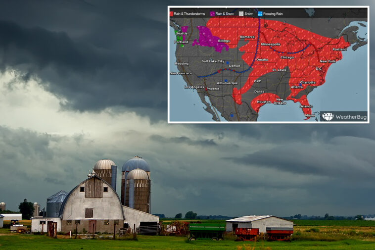
A multiday severe weather threat is expected to intensify Wednesday, affecting more than 135 million people across the Midwest and Northeast through Thursday, with storms capable of producing large hail, damaging wind gusts, and tornadoes.
A large dip in the jet stream is now positioned over the Midwest, helping trigger daily thunderstorms as it slowly moves eastward through the week.
Dew points in the 50s and low 60s, paired with strong daytime heating, will help fuel all modes of severe weather, while also raising the risk of localized flash flooding.
Supercell thunderstorms developed across the Dakotas on Tuesday, generating hurricane-force wind gusts.
Farther south, 90 mph winds were clocked in Kansas, while two weak tornadoes were confirmed outside the initial severe storm-warned area in Michigan’s Saginaw Valley.
On Wednesday, the focus shifts east as the parent area of low pressure moves into Canada, while its trailing cold front will begin moving through the Upper Midwest.


More than 35 million people across the Midwest are in the bullseye of Wednesday’s severe weather threat, including the Milwaukee and Chicago metro areas.
Large hail and tornadoes will be the main hazards on Wednesday afternoon across parts of southeastern Minnesota, Wisconsin, northern Illinois, eastern Iowa, northern Missouri, and northeastern Kansas, where NOAA has issued a Level 3 out of 5 risk of severe thunderstorms.
Heading into the evening, wind gusts up to 75 mph are expected across Wisconsin before pushing into northern Illinois closer to midnight.
Start your day with all you need to know
Morning Report delivers the latest news, videos, photos and more.
Thanks for signing up!
A second elevated round of severe storms capable of producing large hail across eastern Nebraska, southern Iowa, and the Mid-Missouri Valley well into Wednesday night.
Flash flooding is also likely with repeated rounds of storms and high moisture, with rain rates potentially exceeding more than 2 inches per hour.
Severe storm threat stretches from Texas to the Northeast as Chicago and St. Louis eye intense storms

By Thursday, the threat shifts into the Midwest, with a Level 3 severe thunderstorm risk that covers more than 20 million people across the Midwest, including the Chicago, St. Louis, and Milwaukee metro areas.
The severe weather threat extends into the Ohio Valley and Northeast, encompassing more than 125 million people.
Storms will continue to develop in the afternoon and evening along the cold front as it marches eastward, with all severe weather hazards possible once again.

Additionally, these moisture-rich storms could bring the potential for low-end risk flash flooding, with widespread rainfall totals of 1 to 2 inches possible across Minnesota, Wisconsin, Iowa, and Illinois.
Localized amounts exceeding 2 to 3 inches are possible where storms move more slowly or repeatedly track over the same areas.