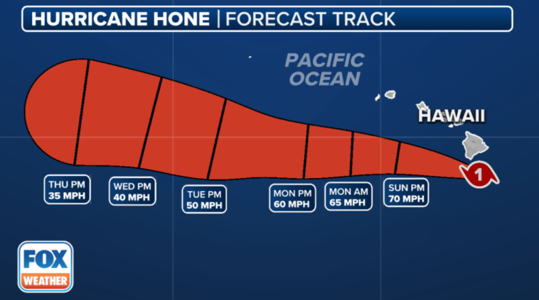
HILO, Hawaii – A Tropical Storm Warning remains in effect for portions of Hawaii as Hurricane Hone brushes by to the south of the archipelago, lashing the region with torrential rain and gusty winds that could have a big impact on those living or traveling to the Aloha State.
Communities on Hawaii’s Big Island, like Hilo, have seen rounds of squally weather, which is expected to continue through at least the start of the new workweek. Flash Flood Warnings were issued for the Big Island of Hawaii early Sunday morning after the National Weather Service said rainfall over some areas intensified, with rain rates of up to 2 inches an hour occurring.
Videos from Hawaii shows the region being blasted by heavy rain and strong winds as the Category 1 hurricane spun off to the south of the region.
One of those videos shows rough surf in Hawaii County, with large waves crashing on shore as powerful winds roar in the background.
Another video shows rain moving into the Pahoa area with dark skies off in the distance.
What is the forecast for Tropical Storm Hone?
Hone is about 600 miles east-southeast of Hilo, Hawaii, and moving on a westerly trajectory. On its current heading, the system is expected to remain in the open waters of the Central Pacific throughout its lifecycle. It will make its closest approach to Hawaii over the weekend.
According to the Central Pacific Hurricane Center, the system could strengthen to near hurricane strength over the weekend while tracking near or south of Hawaii, with a direct landfall unlikely.
What are the expected impacts in Hawaii?
The National Weather Service office in Honolulu is tracking rainfall, surf and wind impacts that will directly and indirectly impact the islands.
Forecasters expect 4-8 inches of rainfall on the southern portions of the Big Island and 2-4 inches of precipitation in mountainous regions on other small islands.
Additionally, increased swells are expected to reach the islands over the weekend and cause life-threatening surf and rip currents.
This is especially true on southern-facing beaches such as Wailea Beach in Maui, Polihale State Park in Kauai and Punaluʻu Black Sand Beach on the Big Island.
Increased gusty winds are expected to impact most, if not all, of the islands, but sustained winds are expected to remain below tropical storm force (40-plus mph) in most communities.
What else is being tracked in the tropics?
The Atlantic is as quiet as weather watchers will ever see the basin in August.
Forecasters expect no tropical cyclone formation through the end of the month due to influxes of dry air and water temperatures that have turned cooler than in past seasons.
It is a different story in the Eastern and Central Pacific, with at least two tropical cyclones and possibly a third during the next week.
The strongest of the two current systems is Hurricane Gilma, which is about 1,900 miles away from Hawaii.
The once-Category 3 hurricane had plenty of warm water and sufficient moisture, which allowed the tropical cyclone to strengthen into a major hurricane.
The National Hurricane Center forecasts weakening during the next several days, but Gilma is expected to remain a hurricane through much of the upcoming weekend.
Similar to Hone, Gilma is moving westerly or west-northwest, in the general direction of Hawaii.
Due to its slow forward speed of about 6 mph, the storm system’s closest approach to Hawaii would likely not occur until around the Labor Day weekend.
The hurricane season in both the Central and Eastern Pacific runs through Nov. 30.


