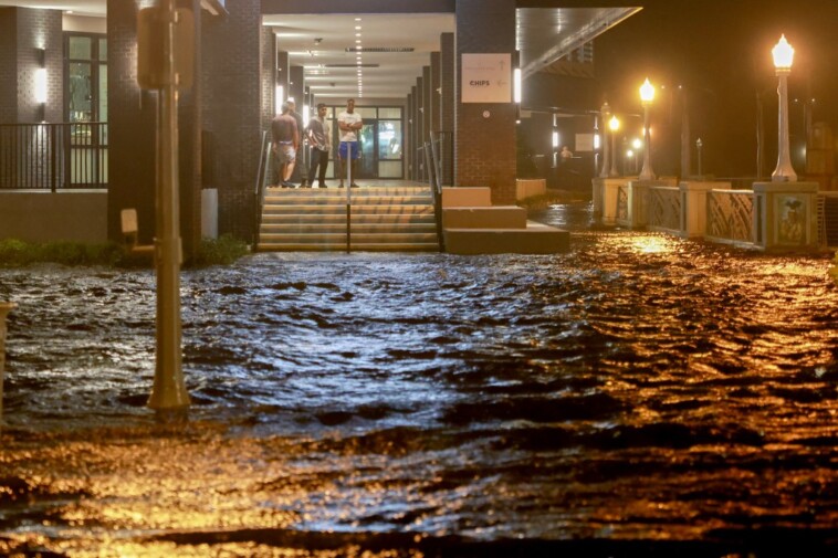
Hurricane Milton slammed into Florida’s west coast Wednesday night as an extremely dangerous storm, bringing a “life-threatening” surge and 120 mph winds that left nearly 2 million people without power and areas inundated with water.
Milton made landfall as a Category 3 storm near Siesta Key in Sarasota County around 8:30 p.m., with winds up to 120 mph, according to the National Hurricane Center — significantly lighter than the 180 mph Milton blew while raging as a Category 5 storm at various points as it traveled across the gulf.
The superstorm was downgraded to a Category 2 at about 10 p.m.
Siesta Key, a barrier island off Sarasota renowned for being one of the 25 best beaches in the world, has about 5,500 residents who are mostly retirement age.
Water levels rose more than 8 feet in nearby Sarasota, the National Weather Service reported, with storm surges up to 5 feet recorded from Naples to Charlotte Harbor, with more inundation likely in Manatee and Sarasota counties.
“Sarasota will continue to see intense wind gusts upwards of 100-plus the next few hours as Milton gradually moves across the region, as well at storm surge as high as 12 feet,” Jordan Overton, a senior meteorologist with Fox Weather, told The Post.
“Power outages are likely. These effects will gradually wane early tomorrow morning as Milton moves away from the county.”
Follow The Post for live updates as Hurricane Milton makes landfall
More than 1.6 million people were without power shortly after 10 p.m., according to PowerOutages.us, with several outages along the peninsula’s western coast and central Florida, where several tornadoes ripped through the region.
The dangerous twisters also took down power lines earlier in the day.
At least nine tornadoes were confirmed as storm systems capable of generating horrific tornadoes swept across Florida and its southern peninsula ahead of Milton’s official landfall on Wednesday, the National Weather Service in Miami confirmed on X.
Fox weather officials said the center of the storm went over Sarasota, as opposed to 15 miles north, resulting in small deviations in the significance over which areas experienced the worst storm surge.
At this time, Tampa’s storm surge is below zero due to offshore winds, according to Fox, with Port Manatee seeing just over a foot of surge.
Downtown Sarasota has experienced more than half a foot of rain, with another 1 to 3 inches expected, weather officials said.
Just north in Brandon — 13 miles from Tampa — the area is being walloped with wind gusts in excess of 80 to 100 mph, Overton confirmed, resulting in at least 20 transformer explosions.
The storm’s landfall just south of Tampa Bay was fortuitous, however — if it struck the heart of the bay, or even north of it, forecasters feared it would result in one of the most dangerous storm surges in US history.
Tampa Bay is almost tailor-made for dangerous storm surges. Shallow waters offshore cause waves to pile up as they push towards land, while the bay’s shape and opening further compress the approaching water.
Most of the surrounding communities sit at elevations below 10 feet, meaning a 13-foot storm surge would leave hundreds of thousands of homes dangerously submerged.
Many feared a direct hit to Tampa Bay could create a calamity to rival Hurricane Katrina in 2005, where overwhelmed levees broke and flooded massive swatch of the city at the cost of more than 1,300 lives.
Over 3 million people who live around Tampa Bay were ordered to evacuate ahead of the storm, with Tampa Mayor Jane Castor cautioning “If you choose to stay … you are going to die.”
Milton made history as it charged toward Florida, peaking as the second strongest Gulf hurricane in history just a day after forming off the Yucatan Peninsula.
Its lowest pressure — commonly used to measure a hurricane’s strength, with lower numbers denoting more power — peaked at 897 millibars, just behind violent Hurricane Rita’s 895 mb in 2005.
Katrina, by comparison, peaked at a strength of 902 mb with winds of 175 mph.
Even as the storm weakened while approaching Florida’s coast — typical behavior for a hurricane — it swelled rapidly in size in the final hours before landfall, stretching to more than 250 miles in diameter from 175 in just a matter of hours.
Travelling on a northeasterly course, Milton’s effects are being felt across the entirety of Florida — just two weeks after Hurricane Helene devastated portions of the state.
But while Helene traveled north into the heart of the US south — wreaking chaos with severe flooding that led to at least 230 deaths — Milton will mercifully blow out the eastern end of Florida and into the Atlantic Ocean.
With Post wires


