
One year after the Palisades and Eaton fires exploded across Los Angeles County, the flames are gone — but the devastation remains locked in place.
Driven by Santa Ana winds, extreme drought and record-dry conditions, the twin disasters ignited on the same January day in 2025 and burned strong for more than three weeks.
What the images show now is absence. Streets that once held family homes are still scraped down to dirt. Empty lots sit fenced and silent, tagged with permits but no progress. Charred trees stand without replacement, their blackened limbs marking where shade and backyards once were.
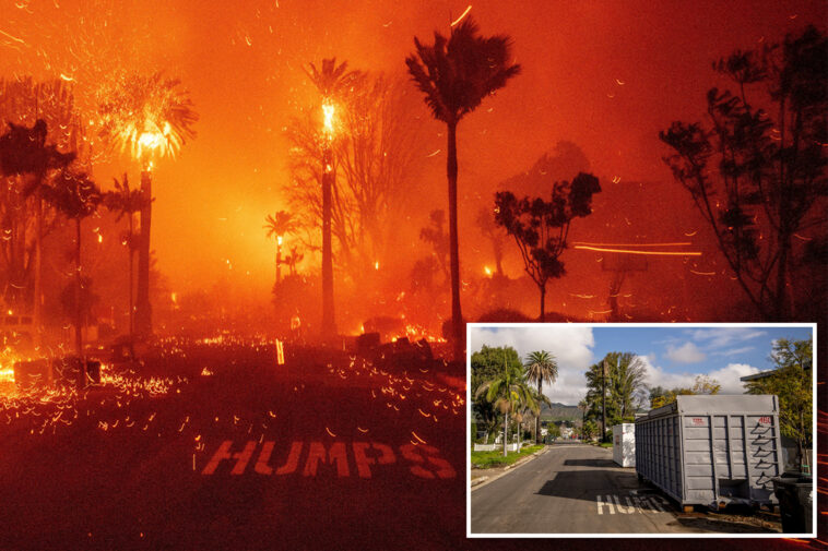
On Jan. 7, 2025, the Palisades Fire tore through Pacific Palisades as powerful Santa Ana winds pushed flames downhill from the Santa Monica Mountains. Embers flew far ahead of the fire line, igniting homes block by block.
Now El Medio Avenue, photographed Jan. 5, 2026, remains hollowed out. A dumpster sits where a house once stood. Storage pods replace homes. Trees remain charred, their blackened limbs frozen in the moment the firestorm passed through.
A firefighter pulls a hose in front of a burning home as the Palisades Fire rapidly expands, fueled by months of drought and wind gusts reaching up to 80 mph. Aircraft were repeatedly grounded overnight as winds intensified.
Now it is just an empty lot. The sidewalk has been cleared. Grass grows where walls once stood. The structure is gone — along with everything that made it a home.
Nearly every one of the roughly 172 manufactured homes in the Pacific Palisades Bowl Mobile Estates was engulfed and destroyed by the Palisades Fire. The park — one of the few affordable housing options on the coast — was a tight-knit enclave of retirees, teachers, artists and families whose homes once sat just up the road from Will Rogers State Beach.
Debris removal has stalled amid disputes over ownership and cleanup responsibility, and former residents — scattered across Southern California and beyond — remain displaced and uncertain whether they’ll ever be able to come home.
Embers stormed through the Palisades as fire spread across 37 square miles, killing 12 people and destroying almost 7,000 structures.
Officials promised fast recovery and fewer barriers. What stands instead are empty lots — a visual record of delays and uncertainty.
Flames climbed hillsides for days. Fire retardant drops were halted when winds became too dangerous, forcing crews into ground-only defense across steep terrain.
Today, the hills are quiet. Rebuilding is sparse. The absence of homes is unmistakable.
Firefighters battled flames at Pacific Palisades Bowl as the fire pushed toward the coast.
Now at 1632 Pacific Coast Highway, the burned site on Driftwood Drive marks where a home once stood. The entire Bowl Mobile Estates community was destroyed.
Long stretches of Pacific Coast Highway in Malibu were once lined with homes set close to the road — a continuous ribbon of residences marking the drive through the fire-prone coastline. Among them stood an iconic home, recognizable for its distinctive entryway, a familiar sight to drivers moving along PCH.
Now that stretch of highway is broken. The home is gone. The entryway still stands, opening onto an empty lot. Where houses once lined the road, there are gaps — exposed ground, cleared debris, and silence — visual proof of how entire sections of PCH became victims of the Palisades Fire.
Crews fought flames inside Pacific Palisades Bowl Mobile Estates as fire raced through tightly packed manufactured homes. Winds drove embers from roof to roof, overwhelming defenses.
Today, burned debris still litters the ground. Rusted metal and ash remain scattered across the site. The community, once 172 homes and one of the few affordable housing options in Pacific Palisades — is still waiting for answers.
Aerial views capture the full scale of the destruction. In January 2025, the landscape is dark and scorched — hillsides burned down to bare earth, neighborhoods reduced to skeletal frames, streets choked with ash and debris.
Most parcels remain vacant, with few signs of rebuilding. Where dense neighborhoods once filled the hills and foothills, there are now wide stretches of open land.
Together, the Palisades and Eaton fires destroyed more than 16,000 structures and claimed 31 lives — losses that remain visible from above long after the flames were extinguished.
One lot stands out, packed with burned-out cars, their frames scorched and clustered together, frozen where they were abandoned as the fire tore through the area. There is no sign of rebuilding here — only the residue of how quickly everything unfolded.
The Eaton Fire ignited on Jan. 7, 2025, in Eaton Canyon and was driven rapidly downhill by powerful Santa Ana winds. The fire killed at least 19 people, destroyed more than 9,000 buildings, and burned for 24 days before it was fully contained — leaving scenes like this behind.
During, and one year after, the Eaton Fire, the images capture how brutally fast Altadena was overrun.
On Jan. 8, 2025, residents race past a burning liquor store on a motorbike as flames tear through the block behind them.
One year later, the liquor store is gone. The building beside its sign has vanished too. What remains is an empty lot, scorched pavement, and battered signage, a blunt reminder of how quickly a neighborhood was erased, and how little has returned.