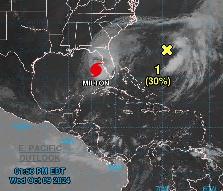
A low pressure system near Bermuda has very little chance of developing into a tropical storm — meaning Floridians can breathe slightly easier, even as they brace for the impacts of Hurricane Milton.
The system — which would be named Nadine if it developed into a tropical storm — is bringing thunderstorms and heavy rain to the waters about 300 miles southwest of Bermuda and has been fluctuating between a 20% and 40% chance of developing into a cyclone.
But forecasters from the National Hurricane Center (NHC) are giving it a 30% chance of developing further in the next 48 hours — and say the odds are diminishing by the hour.
“Upper-level winds are expected to become too strong for further development tonight or into Thursday,” NHC said in its report at 2 p.m. Wednesday.
Even if the storm did develop into Nadine, Americans on the mainland have little to worry about — the system is headed east and straight out into the Atlantic Ocean.
“It’s going straight out to sea, it wouldn’t affect anybody,” Fox Weather meteorologists told The Post.
The news is sure to be a sigh of relief for Americans, who are still reeling from the devastation Hurricane Helene wrought across the South at the end of September.
Entire communities were washed out across Appalachia as severe rainfall sparked catastrophic flooding. At least 230 people have been confirmed killed by the storm.
Almost exactly two weeks later, Florida is battening down to face Hurricane Milton — which has clocked in as one of the most powerful hurricanes to ever form in the Gulf.
Milton is expected to strike Florida late Wednesday night or early Thursday, with current predictions suggesting it will strike just south of Tampa Bay.
But forecasters caution the storm could still strike Tampa itself — which would be devastating for the low-lying city as storm surges up to 13 feet could flood the streets.


