
PITTSBURGH – A powerful storm system that brought severe weather to the central US on Sunday and Monday will continue to charge east on Tuesday, fueling a 2,000-mile threat zone stretching from the Northeast to Texas.
Extreme weather has been dominating the headlines since the weekend, with numerous reports of thunderstorms slamming communities with hurricane-force wind gusts, massive hail the size of teacups smashing windshields and tornadoes knocking over trains.
Now, as those communities work to pick up the pieces, more than 69 million people from New York to Texas will need to keep an eye on the sky as forecasters remain concerned that powerful storms could again produce large hail, damaging wind gusts and even some tornadoes.
The highest threat zone has been highlighted across two areas of the US, with NOAA’s Storm Prediction Center (SPC) placing portions of Texas and Oklahoma, as well as communities from Indiana and Kentucky to New York state, in a Level 3 threat on its 5-point severe thunderstorm risk scale.
On Tuesday afternoon, a Severe Thunderstorm Watch was issued for about 8 million people in parts of Indiana, Kentucky, Ohio and West Virginia until 7 p.m. ET.
Flooding, too, is a concern, as heavy precipitation inundates communities in the Plains and Midwest.

Severe storms threaten Ohio Valley, interior Northeast
Ongoing storms from Monday night continued into Tuesday morning as the expansive system continued pushing off to the east across the central US.
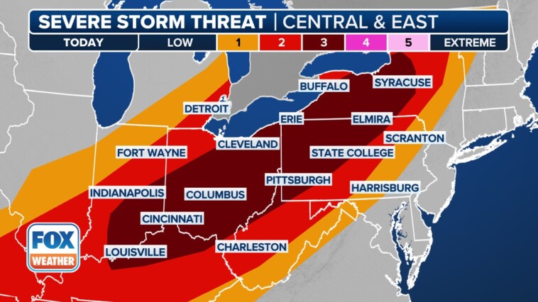
The Level 3 severe weather threat from the Ohio Valley to the Northeast on Tuesday includes cities like Louisville in Kentucky, Columbus and Cleveland in Ohio, Pittsburgh and Erie in Pennsylvania and Buffalo and Syracuse in New York.

The FOX Forecast Center says the greatest threat from these storms will be damaging wind gusts and large hail, but an isolated tornado cannot be ruled out.
“It depends on where you’re at and the timing for when these storms arrive,” FOX Weather Meteorologist Kendall Smith said.
Severe weather rocked parts of Missouri earlier on Tuesday morning, with thunderstorms producing 91-mph wind gusts in Springfield. In addition, schools in Ozark, Missouri, were told to shelter in place during a Tornado Warning.

There have also been numerous reports of trees and power lines down in Freistatt, Monett and Aurora.
Renewed severe weather threat in southern Plains
There’s also a second area of this massive threat zone in portions of Texas and Oklahoma where people need to keep an eye on the sky Tuesday.

“We have just a huge stretch here,” FOX Weather Meteorologist Britta Merwin said. “The southern part also has a bull’s-eye, a 3-out-of-5 potential here for severe weather. Part of the kicker here for Texas is going to be that potential for very large hail.”
Communities in this increased-risk zone include Wichita Falls, Abilene and Midland in Texas.
Plains, Midwest face heightened flash flood threat
Heavy rain is also expected to lead to flash flooding in portions of the Plains and Midwest on Tuesday.

NOAA’s Weather Prediction Center (WPC) says the threat of flooding will stretch from Texas to the Great Lakes on Tuesday. However, a Level 3 out of 4 flood risk has been highlighted for portions of Texas and Oklahoma, including cities like Wichita Falls and Oklahoma City, Oklahoma.