
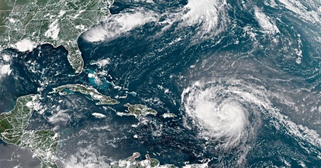
Hurricane Erin, the first hurricane of the 2025 season in the Atlantic, was graded a Category 3 on Sunday.
WESH reported the storm is heading north, away from the coastline of the United States, and it was about 170 miles north of San Juan, Puerto Rico, around 8:00 a.m.
As the hurricane sustains winds of 125 miles per hour, the outlet said “The outer bands of Erin are expected to produce heavy rainfall through Sunday across the northern Leeward Islands, the Virgin Islands and Puerto Rico.”
In a social media post early Sunday, the National Hurricane Center said the storm was moving north and “Tropical Storm Warning has been issued for the Turks and Caicos Islands.”
The center later advised the hurricane’s outer rainbands were producing gusty winds and heavy rains in the Virgin Islands and Puerto Rico.
Officials also noted that “The risk of dangerous and life-threatening rip currents is expected to increase at beaches along the U.S. east coast over the next few days due to Hurricane #Erin.”
According to the WESH article, the center said the storm’s intensity will fluctuate over the next few days.
Meanwhile, video footage posted Saturday shows NOAA Hurricane Hunters and the U.S. Air Force’s 53rd Weather Reconnaissance Squadron flying into the eye of the storm to collect data.
The clip shows crew members inside what looks like a circle of clouds:
According to the NOAA website, hurricanes are one of the most powerful types of storms that are known for their strong winds, storm surge flooding, and heavy rainfall.
“Hurricanes, known generically as tropical cyclones, are low-pressure systems with organized thunderstorm activity that form over tropical or subtropical waters. They gain their energy from warm ocean waters,” the site read.
“As storm systems strengthen into hurricanes, the surface winds move continuously in a circular motion. Meteorologists refer to this pattern as ‘closed circulation,’” it stated.