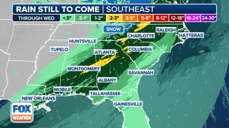
A powerful two-pronged winter storm spanning nearly 2,000 miles has brought stark contrasts across the nation this week. While parts of the Northeast brace for icy conditions, the South faces the threat of torrential downpours and flash flooding.
Travelers should anticipate significant disruptions, while residents should prepare for potential floods, severe thunderstorms, strong winds and heavy snowfall.
Multiday flash flood threat in South
Multiple rounds of heavy rain will drench the Deep South, particularly in parts of Texas, Louisiana, Alabama and Georgia, according to the FOX Forecast Center. Rain totals will range from 2-3 inches, with locally higher amounts of more than 5 inches possible.
The worst rain is expected in places such as Louisiana and southern Alabama. Additionally, a low threat of severe weather is possible Wednesday. Damaging wind gusts and a tornado or two will be possible as the cold front rapidly moves through.
Days of rain, snow to soak Northeast
The Northeast will experience a different kind of winter weather.
Rounds of beneficial rain will soak the Northeast and the Interstate 95 corridor likely through the early hours of Thursday, according to the FOX Forecast Center. Areas along I-95 could receive 3-5 inches of rain.
The second round of rain will come Wednesday with a much larger system, as a powerful cold front drenches the eastern third of the Lower 48.
Wednesday is shaping up to be a washout, with an elevated risk of flash flooding along the I-95 corridor, according to the FOX Forecast Center. This rain will arrive well ahead of the advancing cold front, driven by tropical-like moisture streaming out of the Southeast.
The most significant impacts are expected from New York City to Boston. Some locations could see more than 3 inches of rain from both storm systems combined.
While this rain won’t entirely eliminate drought concerns, it provides a meaningful boost as the new year approaches, according to the FOX Forecast Center.
As colder air rushes back into the region behind the cold front fueling Wednesday’s rainfall, rain could mix with or change over to snow in parts of the interior Northeast and New England by Wednesday night.
However, due to the wet ground and warmer temperatures before the winter weather arrives, it’s difficult to predict where snow will fall and how much could accumulate.
Next lake-effect snow event to arrive in Great Lakes on Wednesday
The Great Lakes region, already battered by recent snowstorms, is facing another round of lake-effect snow expected to start Wednesday and continue into Friday.
A strong snow band is expected to develop off lakes Erie and Ontario, but its exact position is still uncertain, according to the FOX Forecast Center.
If winds shift more to the southwest, the heaviest snow may target western New York. Otherwise, lakeshore areas from Lake County in northeastern Ohio northeastward to parts of northern Ashtabula County in Ohio and Erie County in Pennsylvania could see the biggest impacts.
Snowfall patterns may shift temporarily with a secondary front Wednesday night, but heavy snow is likely for lakeshore communities during this event.


