
Hurricane Melissa strengthened into a Category 4 storm Saturday evening, with winds reaching 140 mph as it barrels towards Jamaica and other Caribbean Islands.
Heavy rainfall, flash floods, and high-speed winds were predicted for Sunday through Tuesday, with the eye of the storm reaching Jamaica late Monday or early Tuesday.
“Seek shelter now,” the National Hurricane Center warned on Sunday.


“Damaging winds and heavy rainfall (Sunday) and on Monday will cause catastrophic and life-threatening flash flooding and numerous landslides before the strongest winds arrive Monday night and Tuesday morning.”
The NHC is also warning of hurricane conditions expected in Cuba, Haiti and the Dominican Republic. Life-threatening flooding is predicted for Turks and Caicos and the Bahamas.
At least two people were killed in Haiti in a landslide caused by flooding in Port-au-Prince on Thursday, according to Haiti’s Civil Protection Agency. The UN has set up more than 100 emergency shelters across the island nation, where many fleeing gang violence live in makeshift homes, according to the Associated Press.
The storm will strengthen into a Category 5 hurricane this evening, said the NHC, roughly when it’s predicted to hit Jamaica.


Hurricane Melissa will likely be the strongest hurricane to hit the island since records have been kept, according to hurricane researcher Michael Ferragamo on X.
The Jamaican government shut down the island’s main airport in Montego Bay, and residents have been warned that power lines will likely be affected by the storm.
So far, the storm has damaged almost 200 homes and knocked out power lines in the Dominican Republic.

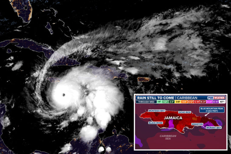
The NHC predicts 15 to 30 inches of rainfall through Wednesday, but said up to 40 inches is possible.
The torrential rainfall is considered unusual, even for slow-moving storms like Melissa, according to the Associated Press.