
See more of our coverage in your search results.

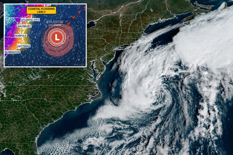
A powerful nor’easter spinning off the North Carolina coast is expected to bring coastal flooding, beach erosion, gusty winds, dangerous surf and rip currents to parts of the Mid-Atlantic and Southeast coasts through Thursday. This storm has also been tagged by the National Hurricane Center as Invest 93L, indicating that the storm has the potential to take on some subtropical or tropical characteristics. The invest designation also means that the NHC will deploy additional forecast tools to track the storm. 93L is currently forecast to remain offshore and begin to pull away from the coast by the end of the week.
THE TAKEAWAY
- Nor’easter to bring coastal flooding, beach erosion, gusty winds and dangerous surf across the North Carolina and Mid-Atlantic coasts through Thursday.
- The storm is being monitored by the National Hurricane Center and could take on subtropical or tropical characteristics.
- A mandatory evacuation is in effect on Hatteras Island as storm conditions are expected to worsen, with the potential for significant ocean overwash.
A powerful nor’easter spinning off the North Carolina coast is expected to bring coastal flooding, beach erosion, gusty winds, dangerous surf and rip currents to parts of the Mid-Atlantic and Southeast coasts through Thursday.

This storm has also been tagged by the National Hurricane Center (NHC) as Invest 93L, indicating that the storm has the potential to take on some subtropical or tropical characteristics.
The invest designation also means that the NHC will deploy additional forecast tools to track the storm.
NOR’EASTER FURY ‼️: FOX Weather Storm Specialist Mike Seidel is slammed by a wave in Rodanthe, North Carolina, where a brewing nor’easter is expected to bring days of dangerous surf, coastal flooding and strong winds. Stay with FOX Weather as we bring you LIVE updates on air and… pic.twitter.com/EvtoMRbvv7
— FOX Weather (@foxweather) October 19, 2026
93L is currently forecast to remain offshore and begin to pull away from the coast by the end of the week.

Regardless of tropical development, North Carolina’s Outer Banks and the Delmarva coasts will see days of coastal high tide flooding, gusty winds and beach erosion.

Few places are more vulnerable than the area around Cape Hatteras in the Outer Banks, where a decades-long battle against coastal erosion has reached a crisis point, with 32 homes collapsing into the ocean since 2020.

A mandatory evacuation is in effect on Hatteras Island as storm conditions are expected to worsen, with the potential for significant ocean overwash.


The main concern for the Outer Banks region will be prolonged periods of wind gusts over 40 mph, fueling moderate coastal flooding and destructive waves.
Parts of North Carolina Highway 12, the primary route through the Outer Banks, are closed due to flooding. The highway is frequently overwashed during coastal storms.

The worst of the flooding will stretch from the Outer Banks into Chesapeake Bay and up through Ocean City, Maryland, where water levels are expected to rise more than two feet above normal during high tide.
According to the FOX Forecast Center, the worst impacts will last through late Wednesday evening and into Thursday.
Coastal flood alerts are active across coastal North Carolina and Virginia.